
GPS Map Camera: Photo Maps
Map Camera Lite: Photo Maps, Weather, unaddressed place detection & live photo!
GPS Map Camera: Photo Maps is developed and provided by Frisco Apps Inc.. LDPlayer offers the download service only.

Overview

FAQ
Run GPS Map Camera: Photo Maps on PC with LDPlayer
GPS Map Camera: Photo Maps is a Photography application developed by Frisco Apps Inc., but with the best Android emulator-LDPlayer, you can download and play GPS Map Camera: Photo Maps on your computer.
Running GPS Map Camera: Photo Maps on your computer allows you to browse clearly on a large screen, and controlling the application with a mouse and keyboard is much faster than using touchscreen, all while never having to worry about device battery issues.
With multi-instance and synchronization features, you can even run multiple applications and accounts on your PC.
And file sharing makes sharing images, videos, and files incredibly easy.
Download GPS Map Camera: Photo Maps and run it on your PC. Enjoy the large screen and high-definition quality on your PC!
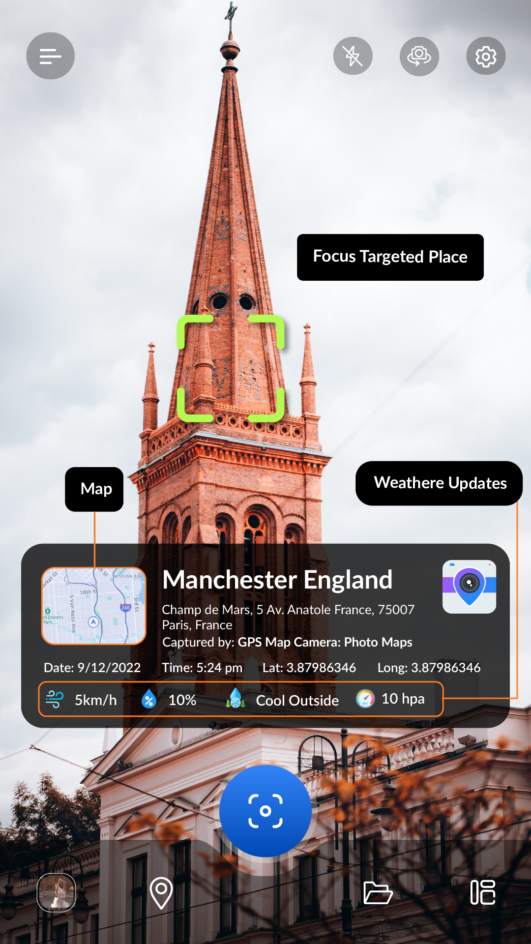
GPS Map Camera & Photo Maps is a mobile application that combines the power of GPS location live tracker and location changer with the convenience of a Camera App Lite and Live Photo. This GPS application is designed to make it easy for users to capture live photos and geolocation while also keeping track of the exact location where the media captured photos. The GPS Map Camera lite app comes with a lot of features, including Photo Maps, Weather, unaddressed place detection & live photo, GPS MAP Camera Lite-Time Stamp, Datetime, Latitude, Longitude, Weather, Magnetic field, Compass, and my altitude to Your App Camera Photos and more.One of the key features of the GPS Map Camera App is its ability to provide users with precise latitude and longitude data and Geotag Photos & Add GPS Location Application. This feature allows users to pinpoint the exact location where a live photo or live location photo was captured, which can be incredibly useful for a variety of applications. For example, a photographer might use this feature to keep track of the locations where they have taken photos for their portfolio.
Another powerful feature of GPS Map Camera lite is its GPS Location Tracker. This feature allows users to track their live location in real-time, which can be useful for an application, such as hiking, running, or cycling. By using this feature, users can keep track of their progress and ensure that they are on the right track.
Interesting Feature
👉 GPS MAP Camera Lite
👉 Live Location and Live Photo Tracker
👉 Find photo location stamp
👉 Geotagged Camera & gps location tracker app
👉 Put Longitude, Latitude, Address, Date-Time, Location stamp to Photos
👉 Get Live Location image stamp with simple camera GPS
The Map Camera lite feature of GPS Map Camera is another powerful tool that users can take advantage of. With this feature, users can add a map stamp-Time Stamp and geotag to their Geotag Photos & Add GPS Location. This can be incredibly useful for of mobile applications, such as travel and live location photo blogging or documenting a hiking trip.
In addition to these features, GPS Map Camera lite also comes with a variety of other tools and features that users can take advantage of. For example,
the app includes a GPS Track Locator, which can be used to find nearby points of interest or navigate to a specific location gps location tracker. The app also includes a variety of weather tools, such as live weather updates and forecasts, which can be useful for planning outdoor activities.
Overall, GPS Map Camera lite is a powerful mobile application with the power of GPS live location tracking with the convenience of a Camera lite app. With its precise latitude and longitude data, real-time GPS tracking, and map camera features, this app is an incredibly useful tool for anyone who wants to document their travels or keep track of their live Location Tracker while on the go.
Screenshots and Videos of GPS Map Camera: Photo Maps PC


How to Download and Run GPS Map Camera: Photo Maps on PC
 1
1Download and install LDPlayer on your computer
 2
2Locate the Play Store in LDPlayer's system apps, launch it, and sign in to your Google account
 3
3Enter "GPS Map Camera: Photo Maps" into the search bar and search for it
 4
4Choose and install GPS Map Camera: Photo Maps from the search results
 5
5Once the download and installation are complete, return to the LDPlayer home screen
 6
6Click on the game icon on the LDPlayer home screen to start enjoying the exciting game