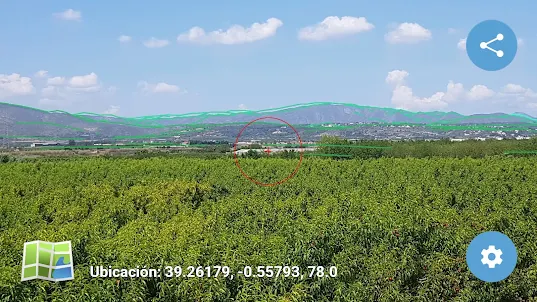
Horizoner is basically a horizon simulator, hence its name. It is an application that simulates the landscape visible from a given point, reproducing the summit lines of existing mountains.
Which mountain is that? Its main utility lies in the fact that, by pointing to any point in this simulated landscape, the app returns its coordinates and altitude, also locating the point on a map. It is, therefore, an interesting tool for identifying mountains.
And not only peaks! To identify other elements of the landscape, such as villages or farmhouses, which can be difficult to reference visually on the simulation, Horizoner, if so indicated, will automatically take a photo of the landscape. Subsequently, after adjusting the simulated horizon to the photo, and after pointing to a point in the photo, the app will return its location on a map as in the first case.
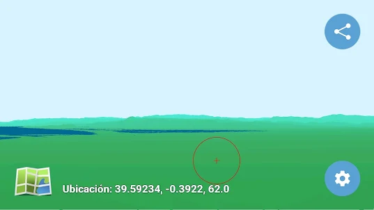
Where is this mountain? In addition, Horizoner can be used in reverse. That is, we can indicate a point on the map and the app orients the device to focus on the point in question (a mountain, a castle, etc.) after which, simulating the landscape again, Horizoner places the point entered in the simulated landscape.
With Horizoner on your cell phone you can have a panoramic explanatory panel on each summit you visit! Horizoner also allows you to simulate landscapes in panoramic mode (only available in Premium version), bringing the simulation closer to what you are really seeing from the mountain. Also in this Premium version it is possible to simulate landscapes in a more realistic way by coloring the simulation.
What view will there be from that mountain? The point of view and orientation need not necessarily be those of the user (data that by default are taken through the GPS and the compass of the mobile), but it is possible to enter any location, any orientation, and even any viewing height, which opens the door to make simulations of landscapes in which we are not physically or to test what would be seen from a tower that we placed at a certain point ... or from an airplane!
Who will be interested in it? Horizoner will be of great interest for the mountaineering enthusiast, for the tourist in general, and even for the navigator, since although the scope of operation is the Spanish peninsular territory, it can also be used offshore, simulating in this case the coast as if it were a coasting book. It is also a useful instrument to determine the coordinates of distant points, something like a remote GPS, which will be useful in professional work (forestry surveillance, engineering, etc.).
Horizoner has been extensively tested and its validity has been proven through intensive field trials.Start creating your own horizons with Horizoner!
Which mountain is that? Its main utility lies in the fact that, by pointing to any point in this simulated landscape, the app returns its coordinates and altitude, also locating the point on a map. It is, therefore, an interesting tool for identifying mountains.
And not only peaks! To identify other elements of the landscape, such as villages or farmhouses, which can be difficult to reference visually on the simulation, Horizoner, if so indicated, will automatically take a photo of the landscape. Subsequently, after adjusting the simulated horizon to the photo, and after pointing to a point in the photo, the app will return its location on a map as in the first case.
Where is this mountain? In addition, Horizoner can be used in reverse. That is, we can indicate a point on the map and the app orients the device to focus on the point in question (a mountain, a castle, etc.) after which, simulating the landscape again, Horizoner places the point entered in the simulated landscape.
With Horizoner on your cell phone you can have a panoramic explanatory panel on each summit you visit! Horizoner also allows you to simulate landscapes in panoramic mode (only available in Premium version), bringing the simulation closer to what you are really seeing from the mountain. Also in this Premium version it is possible to simulate landscapes in a more realistic way by coloring the simulation.
What view will there be from that mountain? The point of view and orientation need not necessarily be those of the user (data that by default are taken through the GPS and the compass of the mobile), but it is possible to enter any location, any orientation, and even any viewing height, which opens the door to make simulations of landscapes in which we are not physically or to test what would be seen from a tower that we placed at a certain point ... or from an airplane!
Who will be interested in it? Horizoner will be of great interest for the mountaineering enthusiast, for the tourist in general, and even for the navigator, since although the scope of operation is the Spanish peninsular territory, it can also be used offshore, simulating in this case the coast as if it were a coasting book. It is also a useful instrument to determine the coordinates of distant points, something like a remote GPS, which will be useful in professional work (forestry surveillance, engineering, etc.).
Horizoner has been extensively tested and its validity has been proven through intensive field trials.Start creating your own horizons with Horizoner!
Open up