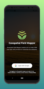
Introducing "Geospatial Field Mapper" – Your Ultimate Geospatial Mapping Companion! Unleash the power of precision agriculture with Geospatial Field Mapper, the innovative android app that revolutionizes the way you collect, manage, and geolocate fields for project-specific crop data. Whether you're a food processing enterprise, a researcher, or an agriculture enthusiast, this app empowers you to make informed decisions while harnessing the potential of attributes, visual data, and seamless data management like never before.
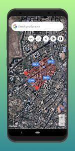
🌾 Seamless Geospatial Mapping Effortlessly map out your fields with precise geolocation technology. Pinpoint the exact coordinates of each field with a simple tap, creating a visual and accurate representation of your agricultural landscape.
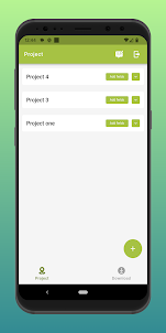
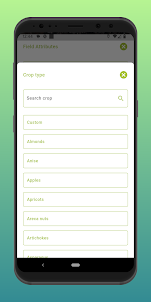
📊 Structured Crop Data Collection and Flexible Attribute Creation: Say goodbye to scattered notes and disorganized data. Geospatial Field Mapper allows you to capture project-specific information about each crop in a structured format. From planting dates and irrigation schedules to growth stages and yield estimates, every crucial detail can be neatly categorized and easily accessible. Tailor your data collection to your unique project needs. Create attributes with values in text, number, or date format, aligning data collection to the specifics of your agricultural endeavors.
📸 Visual Data Integration: Elevate your data with imagery. Enhance each entry with photos, capturing the essence of your fields and crops. Attach photos with a click or upload them, enriching your records for a comprehensive visual experience.
📥 Effortless Data Download: With a simple click, download your collected data in geoJSON format. Seamlessly access your insights and share them with ease.
🗺 Visualize in GIS Platforms: Transform your geoJSON files into actionable insights. Visualize your data on platforms like Google Earth or other GIS tools, enhancing your understanding of your agricultural landscape.
🚀 Towards Analytical Dashboards & Satellite Insights Geospatial Field Mapper's journey doesn't end with data collection. Our ongoing development focuses on providing analytical dashboards and satellite-based insights. Leverage advanced analytics to make informed decisions, optimize resource allocation, and predict trends for smarter farming practices. Embark on a new era of farming intelligence with our upcoming satellite-based insights. Harness the power of satellite imagery to monitor crop health, detect anomalies, and predict yield potential. Stay at the forefront of agricultural technology with this innovative feature.
🔒 Data Security and Privacy:
Rest easy knowing your data is secured. Geospatial Field Mapper prioritizes data security through encryption and secure storage, ensuring the confidentiality of your agricultural information. Embark on a journey toward precision farming with Geospatial Field Mapper. Embrace the power of structured data, geospatial insights, and collaboration to redefine your approach to agriculture. Whether you manage a small-scale plot or vast farmlands, Geospatial Field Mapper equips you with the tools to cultivate success, one geolocation at a time. Join the movement today. Download Geospatial Field Mapper and unleash the potential of your fields, your data, and your future in agriculture.
🌾 Seamless Geospatial Mapping Effortlessly map out your fields with precise geolocation technology. Pinpoint the exact coordinates of each field with a simple tap, creating a visual and accurate representation of your agricultural landscape.
📊 Structured Crop Data Collection and Flexible Attribute Creation: Say goodbye to scattered notes and disorganized data. Geospatial Field Mapper allows you to capture project-specific information about each crop in a structured format. From planting dates and irrigation schedules to growth stages and yield estimates, every crucial detail can be neatly categorized and easily accessible. Tailor your data collection to your unique project needs. Create attributes with values in text, number, or date format, aligning data collection to the specifics of your agricultural endeavors.
📸 Visual Data Integration: Elevate your data with imagery. Enhance each entry with photos, capturing the essence of your fields and crops. Attach photos with a click or upload them, enriching your records for a comprehensive visual experience.
📥 Effortless Data Download: With a simple click, download your collected data in geoJSON format. Seamlessly access your insights and share them with ease.
🗺 Visualize in GIS Platforms: Transform your geoJSON files into actionable insights. Visualize your data on platforms like Google Earth or other GIS tools, enhancing your understanding of your agricultural landscape.
🚀 Towards Analytical Dashboards & Satellite Insights Geospatial Field Mapper's journey doesn't end with data collection. Our ongoing development focuses on providing analytical dashboards and satellite-based insights. Leverage advanced analytics to make informed decisions, optimize resource allocation, and predict trends for smarter farming practices. Embark on a new era of farming intelligence with our upcoming satellite-based insights. Harness the power of satellite imagery to monitor crop health, detect anomalies, and predict yield potential. Stay at the forefront of agricultural technology with this innovative feature.
🔒 Data Security and Privacy:
Rest easy knowing your data is secured. Geospatial Field Mapper prioritizes data security through encryption and secure storage, ensuring the confidentiality of your agricultural information. Embark on a journey toward precision farming with Geospatial Field Mapper. Embrace the power of structured data, geospatial insights, and collaboration to redefine your approach to agriculture. Whether you manage a small-scale plot or vast farmlands, Geospatial Field Mapper equips you with the tools to cultivate success, one geolocation at a time. Join the movement today. Download Geospatial Field Mapper and unleash the potential of your fields, your data, and your future in agriculture.
Open up