If you are a professional photographer, a traveler, an explorer, or just someone who wants to remember where the pictures were taken, this GPS map camera location app is perfect for you.
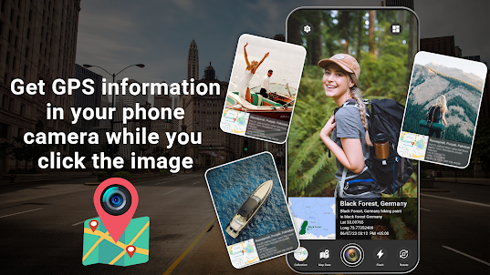
GPS Map Camera is a powerful and intuitive GPS Field Camera app that allows you to capture photos with location information, Geotags, coordinates, time & date stamps, etc...
Great & Interesting Features of GPS Map Camera Application:
✿ Perfect for travelers, photographers, explorers, etc.
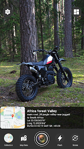
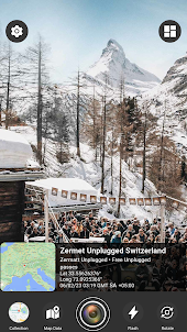
✿ Shows maps of different styles like satellites, terrain, hybrid, etc.
✿ You can switch easily between simple and advanced templates of GPS Map Camera.
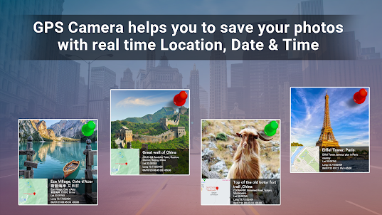
✿ GPS camera photo with location app shows 5 things on photos, like map type, address, Long/Lat, date & time, and time zone.
✿ You can set photo map data as auto or manual.
✿ Very easy and simple user interface (UI) of GPS camera with longitude and latitude.
✿ Beautiful photo gallery to show all your captured photos.
✿ You can share or delete photos directly from the app’s gallery.
✿ You can customize the colors of the geotag text like address, date & time, etc.
GPS Map Camera Geotag Photos app uses your device's GPS to accurately record your location and embed it into your media files. You can choose from a variety of map types, including satellite, terrain, and hybrid, to see exactly where your photos and videos were taken.
GPS Map Camera Geotag Photos app has a user-friendly interface that makes it easy to use. Just open the app, and it will automatically detect your location. You can customize the camera settings to adjust the resolution, quality, and other parameters to suit your needs.
You can choose from a variety of designs, including your name, date, time, and location information. This is perfect for photographers who want to protect their work from unauthorized use or for travelers who want to share their adventures with people.
Required Permissions:
1] Camera: to capture images.
2] Storage: To store captured images in the gallery.
3] GPS: To get latitude/longitude, display your current location on the map, your current time and date, and many other things.
Overall, GPS Map Camera is a must-have app for anyone who wants to capture their experiences with location information embedded in their media files. It's easy to use, has a variety of customization options, and is perfect for both professionals and casual users.
GPS Map Camera is a powerful and intuitive GPS Field Camera app that allows you to capture photos with location information, Geotags, coordinates, time & date stamps, etc...
Great & Interesting Features of GPS Map Camera Application:
✿ Perfect for travelers, photographers, explorers, etc.
✿ Shows maps of different styles like satellites, terrain, hybrid, etc.
✿ You can switch easily between simple and advanced templates of GPS Map Camera.
✿ GPS camera photo with location app shows 5 things on photos, like map type, address, Long/Lat, date & time, and time zone.
✿ You can set photo map data as auto or manual.
✿ Very easy and simple user interface (UI) of GPS camera with longitude and latitude.
✿ Beautiful photo gallery to show all your captured photos.
✿ You can share or delete photos directly from the app’s gallery.
✿ You can customize the colors of the geotag text like address, date & time, etc.
GPS Map Camera Geotag Photos app uses your device's GPS to accurately record your location and embed it into your media files. You can choose from a variety of map types, including satellite, terrain, and hybrid, to see exactly where your photos and videos were taken.
GPS Map Camera Geotag Photos app has a user-friendly interface that makes it easy to use. Just open the app, and it will automatically detect your location. You can customize the camera settings to adjust the resolution, quality, and other parameters to suit your needs.
You can choose from a variety of designs, including your name, date, time, and location information. This is perfect for photographers who want to protect their work from unauthorized use or for travelers who want to share their adventures with people.
Required Permissions:
1] Camera: to capture images.
2] Storage: To store captured images in the gallery.
3] GPS: To get latitude/longitude, display your current location on the map, your current time and date, and many other things.
Overall, GPS Map Camera is a must-have app for anyone who wants to capture their experiences with location information embedded in their media files. It's easy to use, has a variety of customization options, and is perfect for both professionals and casual users.
Open up